SurfVelTools
Geographer and researcher with over a decade of experience developing innovative tools, technologies, and applications using remote sensing to address real-world challenges. Skilled in software design, operational deployment of hardware and technology, and delivering practical training. Passionate about effective project management and clear communication through scientific publications, documentation, and diverse media.

U.S. Geological Survey
Geographer, Hydrologic Remote Sensing Branch | -
As part of the Technology Development and Transfer Team, I work to create new software tools and methods to solve water resource issues.
U.S. Geological Survey
Geographer, Oklahoma-Texas Water Science Center | -
Operationally focused scientist working on water resource problems nationally and at the local level.
U.S. Geological Survey
Geographer, Illinois Water Science Center | -
Operationally focused scientist working on water resource problems in the Great Lakes region.
SurfVelTools
IVy Tools
CameraDCP
NIMS
Prob Concept
River Ice
ML Image Velocimetry

Image Vel Standardization

Training and Teaching
University of Illinois at Urbana-Champaign
Doctorate of Geography, Minor in Civil and Environmental Engineering | -
Texas State University-San Marcos
Master of Science in Geography | -
Texas State University-San Marcos
Bachelor of Science in Physical Geography, Minor in Music | -
Surface Velocity Tools (SVT)
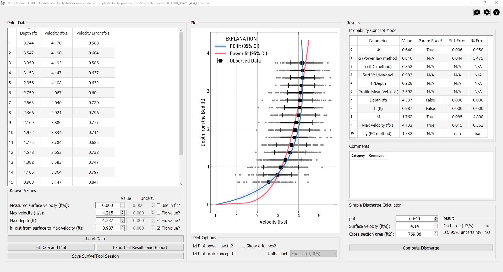
SurfVelTools is a Python application and user interface for computing parameters associated with the Probability Concept method (Fulton and others, in review) parameters using velocity profile data collected in the stationing where the maximum in-channel velocity occurs. SurfVelTools will also compute streamflow (discharge) for a given Probability Concept result given a known cross-sectional area, phi, and surface velocity—all variables measured in the field at a typical surface velocimetry gage. SurfVelTools enables rapid determination of these parameters and streamflow with uncertainties, including profile fit evaluation. Results can be archived and exported for recordkeeping purposes.
Citation: Engel, F. L., 2023, Surface Velocity Tools (SurfVelTools), U.S. Geological Survey software release, https://doi.org/10.5066/P9I5JABK.
Image Velocimetry Tools (IVy Tools)
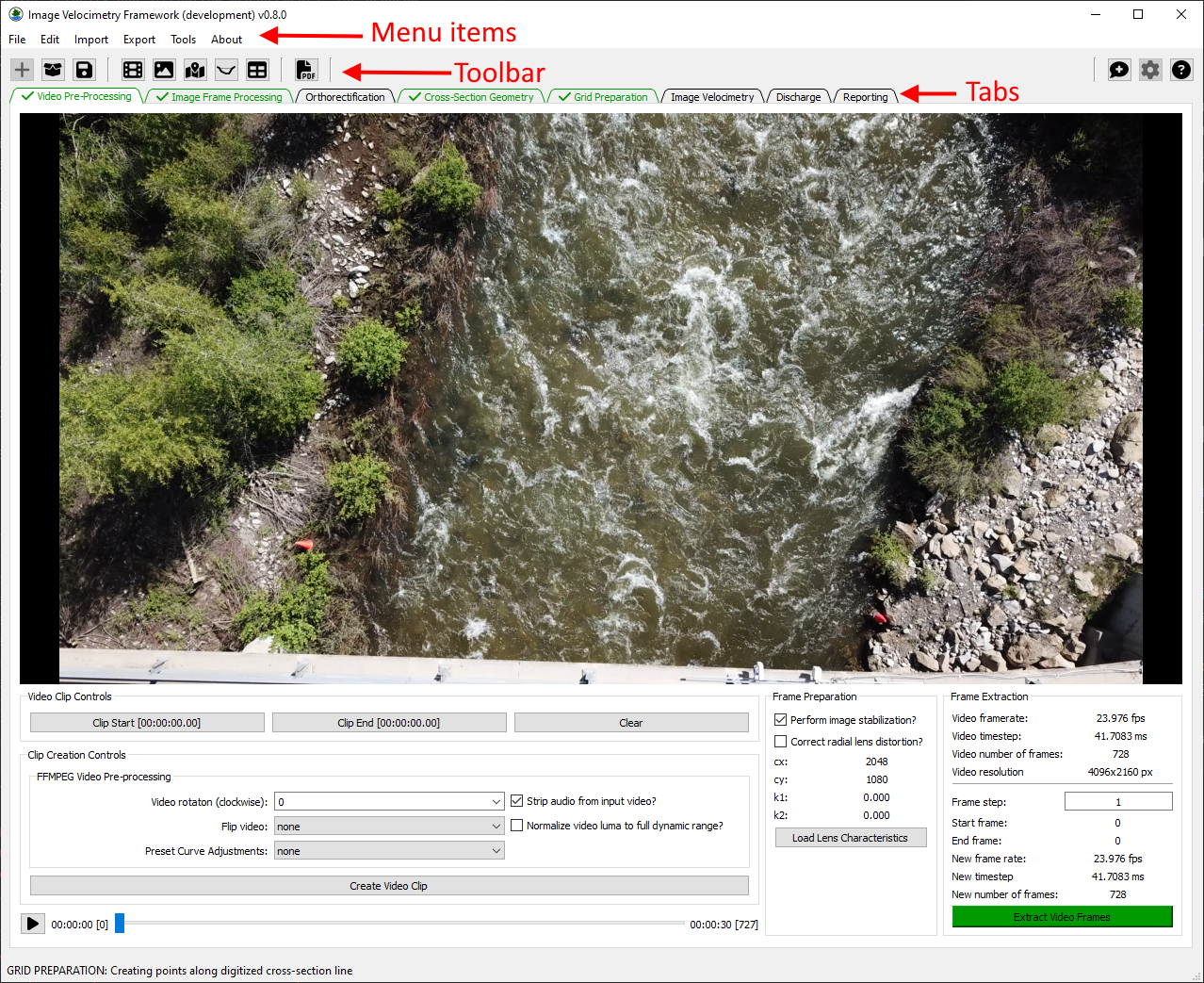
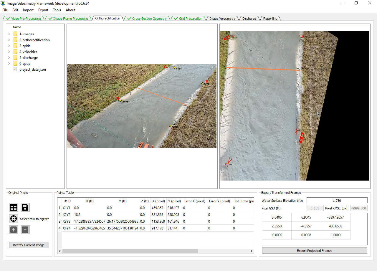
The Image Velocimetry Tools (IVy Tools), or IVy, is a Python
application that provides workflow support for processing video and
imagery into water velocity and streamflow measurements. The program
provides tools that produce consistent imagery input. The application
also supports processing imagery sequences using Space-Time Image
Velocimetry (STIV) algorithms.
Citation: Engel, F. L., and Knight, T. 2025. Image Velocimetry Tools (IVy Tools): U.S. Geological Software Release, https://doi.org/10.5066/P1KMVCNY.
Camera Data Collection Platform (CameraDCP)
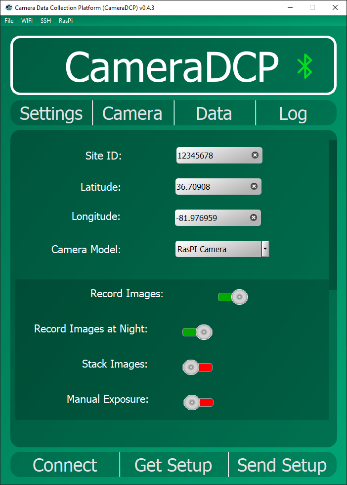
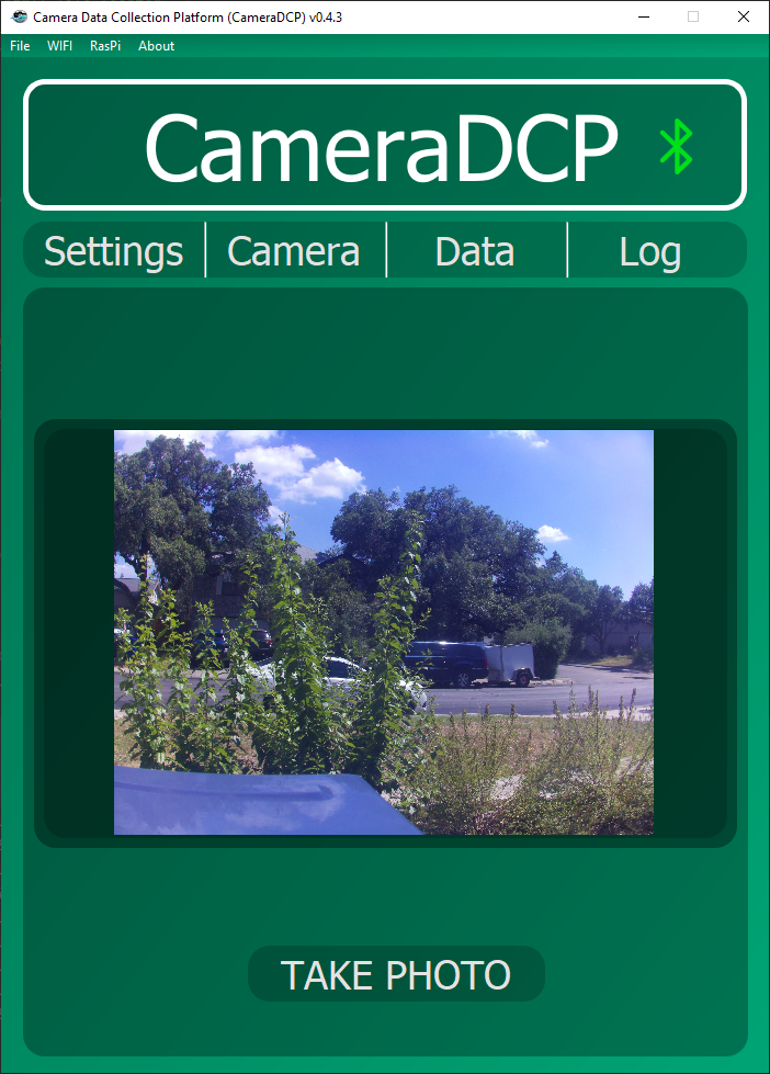
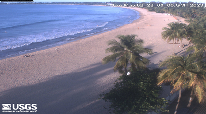
CameraDCP is a sophisticated application designed to enable users to utilize Raspberry Pi single-board computers (SBCs) for the collection of imagery and video from various network cameras or Raspberry Pi camera modules. Designed to supplement a traditional Data Collection Platform (DCP) typically found at U.S. Geological Survey (USGS) gages, CameraDCP specializes in using cameras as observation or measurement sensors. This application supports scheduling measurements based on predefined times, external triggers, or internal level sensing, if available. Additionally, it can telemeter collected data to multiple destinations, including the National Imagery Management System (NIMS).
Built with flexibility and reliability in mind, CameraDCP offers a robust solution for automated imagery data collection in diverse environments. Its integration capabilities and comprehensive scheduling options make it a valuable tool for both field and laboratory applications, enhancing the efficiency of data collection and management processes. The ongoing development and use by the USGS underscore its utility and potential for broad application in scientific and monitoring projects.
Citation: Lee, A.M., Engel, F.L., Andrews, S.J, Nicotra, M.J., and Gyves, M.C., 2024, Camera Data Collection Platform (CameraDCP), U.S. Geological Survey software release, https://doi.org/10.5066/P13SMLIZ.
National Imagery Management System
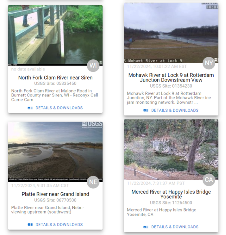
The National Imagery Management System (NIMS) is a scalable cloud infrastructure for hydrologic imagery data. NIMS uses a combination of processes to automatically ingest imagery files from remote monitoring locations at varying time scales. NIMS can also accept non-telemetered images through a bulk image file uploader. NIMS captures over 20,000 images every day from over 800 cameras installed at USGS streamgages across the United States.
Images that are captured by NIMS are used by several other web applications includiding the USGS National Water Dashboard, Monitoring Location Pages, and more.
The Hydrologic Imagery Visualizaiton and Information System (HIVIS) is a fully-featured frontend built to demonstrate the power of the NIMS/
Probability Concept
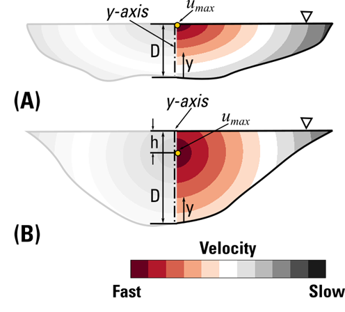
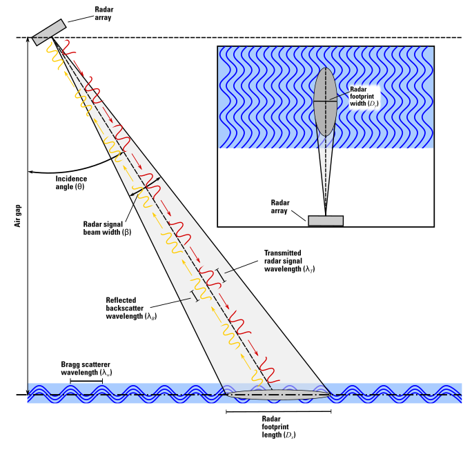
The probability concept is a paradigm change for computing mean velocity and discharge. Sensor technology for measuring mean velocity and discharge has advanced; however, standard streamgaging methods for computing these metrics have remained relatively unchanged since the USGS established its first streamgage at the Rio Grande at Embudo, New Mexico, USA. Standard streamgaging methods rely on integrating depth and velocity data collected from multiple verticals at-a-section to compute a discharge. Depth is measured using instream wading and surveying techniques or manned- or tethered- boats. Velocity is measured using sensors such as mechanical current meters, acoustic Doppler velocimeters ADVs), acoustic Doppler current profilers (ADCPs), and surface water velocity (surface velocity) sensors such as Doppler velocity radars and cameras. Standard streamgaging methods coupled with these sensors are not only used to compute discharge, but they are also used to parameterize the probability concept, where the mean velocity is derived either from (1) measured surface velocities, (2) velocity and depth pairs at a single vertical that coincides with the maximum velocity, or (3) ratio between the mean velocity and maximum velocity at the standard cross section.
The primary advantage of the probability concept is improved operability by computing the discharge immediately after a single site visit and parameterizing the probability concept. Other advantages include (1) ability to compute discharge at sites with complex streamflow conditions that are missed by stage-discharge methods, (2) capacity to augment time-series data where gaps exist, and (3) reduced risk of equipment damage caused by ice-, debris-, and flood-flows when surface velocity sensors are deployed. Disadvantages of the probability concept include (1) environmental bias such as rain and wind and (2) geomorphologic and hydraulic instabilities that may create spatial and temporal variations in the probability concept parameters
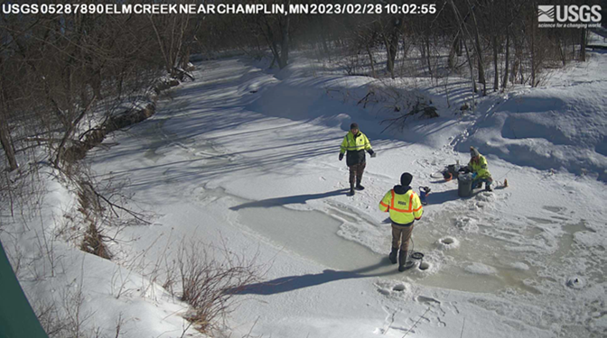
Project title
In this collaborative project with the Stevens Institute, we are developing machine learning models that can identify the presence of river ice using imagery captured by the National Imagery Management System (NIMS) and available through the Hydrologic Imagery Visualization and Information System (HIVIS).
Citation: Ayyad, M., Temimi, M., Abdelkader, M. Henein, M. Engel, F.L., Lotspeich, R.R., and Eggleston, J.R. 2025. RIce-Net: Integrating Ground-Based USGS HIVIS Cameras and Machine Learning for Automated River Ice Detection. Engineering Applications of Artificial Intelligence. https://doi.org/10.1016/j.envsoft.2025.106454.
Using Machine Learning to Improve Image Velocimetry
In this collaborative project with Penn State University, we seek to utilize machine learning (ML) techniques to advance the state-of-the-art of image-based flow measurement. The goal is to automate and improve the image-based measurement workflow with physics-guided deep learning (DL).
Standardizing software for image velocimetry
This collaborative project with the University of Arizona is working on standardizing software and process workflows for conducting image velocimetry. There are several software applications available. Some are open source, while others are not. The implementation, reliability, and procedureal steps used by these applications vary widely. This project is working to produce a standard workflow for image velociemtry. Moreover, this workflow will be used to developing policies and guidance for the USGS application of image velociemtry for computing streamflow.
Training and Teaching
I am passionate about teaching and mentoring USGS staff and scientists at all levels. I develop classes, workshops, and software to help promote the use of novel non-contact methods at USGS. To this end, I have developed and taught several classes.